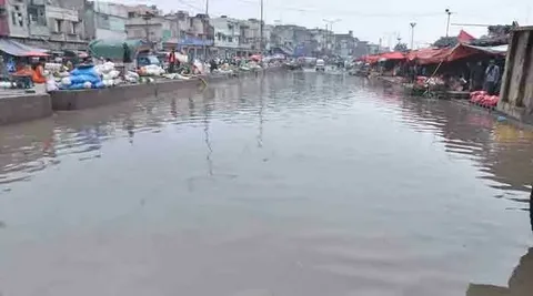
The Leh Nullah flood risk has once again become a matter of serious public concern as monsoon rains continue to batter Rawalpindi and Islamabad. Authorities have confirmed that large sections of the Leh Nullah remain choked with silt, garbage and illegal construction, raising fears of flash flooding in low-lying neighbourhoods. At the same time, the Capital Development Authority has stepped up its Islamabad nullah encroachments demolition campaign, targeting illegal structures built along the city’s storm drains that originate from the Margalla Hills.
Background
Nullah Leh is an eighteen to twenty kilometre long seasonal stream that flows through the heart of Rawalpindi, originating from the Margalla Hills of Islamabad. Until the middle of the twentieth century, this waterway carried clean water that residents once used for drinking purposes. Over the decades, unplanned urban growth around the channel turned it into a flood hazard, and the annual Leh Nullah flood risk now dominates monsoon preparedness discussions in the twin cities. Every year between mid June and mid September, district authorities in Rawalpindi declare a formal flood emergency period for Nullah Leh and its fifteen associated seasonal streams. These waterways have repeatedly overflowed their banks during heavy downpours, submerging residential colonies, damaging property and, in past years, claiming lives. The recurring nature of this crisis has made the Leh Nullah flood risk one of the most closely watched urban safety issues in Punjab. In Islamabad, a parallel and closely connected problem has emerged around the city’s network of nullahs, including Korang Nullah, Saidpur stream and the Sohan River tributaries. These channels have been steadily narrowed by unauthorised housing, shops and land grabbing, which restricts the natural flow of rainwater and increases the likelihood of urban flooding. The Islamabad nullah encroachments demolition drive was launched specifically to reverse this trend before further monsoon damage occurs.
Details
According to district administration officials in Rawalpindi, nineteen vulnerable points along Nullah Leh and the Soan River have been identified for urgent desilting and encroachment removal work. These points include Kattarian, Bangash Colony, Pirwadhai, Dhoke Hassu, Gawalmandi, Javed Colony, Nadeem Colony and several other densely populated localities that sit directly along the drainage path. Despite the scale of the task, funding shortages have repeatedly slowed progress. Officials had originally requested substantial provincial funds for desilting, widening and debris removal along Nullah Leh and thirteen additional storm drains, but only a fraction of the requested amount was actually released. As a direct result, cleaning work has been concentrated mainly around the Gawalmandi Bridge area, while long stretches of the nullah, particularly within cantonment limits, remain clogged with silt and waste. Two danger markers continue to guide emergency response along the channel. The flood threshold at Kattarian stands at eighteen feet, while the Gawalmandi marker is set at seventeen feet. When water levels approach these figures, rescue agencies, Civil Defence volunteers and army personnel from the Triple One Brigade are placed on high alert to assist stranded residents and coordinate evacuation from flood-prone pockets of the city. Parallel to the Rawalpindi effort, the Capital Development Authority in Islamabad has intensified its own anti-encroachment operations. In several recent actions, CDA teams backed by heavy machinery demolished illegally constructed shops, vacant houses and other unauthorised structures built on state land in areas such as Chontra Village and Noorpur Shahan. Officials say the broader Islamabad nullah encroachments demolition campaign is aimed at restoring the natural right of way of the city’s drainage channels so that rainwater can flow freely instead of backing up into residential streets. Not every demolition attempt has proceeded smoothly. In Noorpur Shahan’s Noori Bagh Mohallah, an anti-encroachment operation triggered fierce resistance from hundreds of residents, resulting in clashes involving tear gas, baton charges and injuries to both police personnel and villagers. Legal challenges have also slowed some operations, with the Islamabad High Court temporarily halting demolitions in certain katchi abadis while directing authorities to justify the scope and legality of specific actions.
Quotes
Deputy Commissioner Rawalpindi, Hassan Waqar Cheema, said preparations to deal with flooding along Nullah Leh had been finalised, adding that rescue agencies and Civil Defence teams would remain on standby throughout the monsoon emergency period. He noted that duty rosters had been issued to monitor desilting and encroachment removal progress at each of the identified vulnerable points. A senior WASA official overseeing drainage operations in Islamabad stated that stronger rain spells could quickly raise water levels in Nullah Leh, and confirmed that emergency arrangements had been completed to manage any sudden flooding situation. He further noted that Rawal Dam and Khanpur Dam were both being closely monitored as their capacity has a direct bearing on downstream flood risk. Officials from the Capital Development Authority have maintained that land used for illegal construction along Islamabad’s nullahs was acquired through lawful means, and that ongoing demolition drives form part of the city’s approved master plan. They have stressed that action against unauthorised construction along drainage channels will continue without interruption in order to protect Islamabad from repeat flooding incidents.
Impact
The continued Leh Nullah flood risk carries significant consequences for hundreds of thousands of residents living in low-lying parts of Rawalpindi. Families in neighbourhoods such as Dhoke Hassu, Fazalabad and Nadeem Colony have already begun relocating valuables to safer locations, reflecting the genuine anxiety created by incomplete desilting work heading into peak monsoon weeks. Beyond immediate flood damage, the Islamabad nullah encroachments demolition operations are reshaping the social and legal landscape of the federal capital. Thousands of residents in informal settlements built along or near nullahs face displacement, often without guaranteed resettlement, which has drawn criticism from human rights organisations concerned about due process and adequate compensation. At the same time, unresolved encroachments carry their own regional cost. Blocked and narrowed drainage channels have already been linked to fatal incidents in Islamabad, including flooding in Saidpur Village that swept away vehicles, and a tragic case in DHA Phase 5 where floodwater led to loss of life. Balancing urban safety with the rights of long-settled communities remains one of the central challenges facing both the CDA and Rawalpindi’s district administration.
Conclusion
As the monsoon season continues, authorities in Rawalpindi and Islamabad face mounting pressure to complete desilting, widen constrained channels and finish the Islamabad nullah encroachments demolition drive before the next spell of heavy rainfall arrives. Officials insist that flood monitoring systems, rescue drills and emergency control rooms are in place, yet funding shortfalls and legal disputes continue to slow the pace of on ground work.Going forward, the Leh Nullah flood risk is expected to remain a recurring seasonal story until desilting is fully completed and encroachments along the channel’s entire eighteen to twenty kilometre length are permanently cleared. Residents, civic bodies and rescue agencies alike will be watching water levels at the Kattarian and Gawalmandi markers closely in the coming weeks, as any sustained spell of heavy rain could once again test the preparedness of both cities.
FAQs
Which areas are more likely to get affected by floods?
Low lying neighbourhoods situated directly along seasonal waterways face the highest exposure during heavy monsoon rainfall. In Rawalpindi, localities such as Dhoke Hassu, Javed Colony, Nadeem Colony, Fazalabad, Bangash Colony, Pirwadhai and Gawalmandi sit close to Nullah Leh and are considered the most vulnerable points on the flood risk map, largely because of their proximity to narrow, silt filled sections of the channel. In Islamabad, sectors and villages near Korang Nullah, Saidpur, Bhara Kahu, Banigala and the Sohan River tributaries face similar risks whenever drainage channels are choked by encroachments or debris. Urban planners generally point out that areas built on or near the natural right of way of a nullah, rather than areas simply close to a river, tend to experience the fastest and most destructive flooding because floodwater has nowhere else to go once channels are blocked.
Which areas are flooded in Punjab?
During periods of heavy monsoon rainfall, several major cities across Punjab regularly experience urban flooding alongside Rawalpindi. Meteorological authorities have repeatedly issued urban flooding alerts for Lahore, Gujranwala, Sialkot, Multan and Faisalabad, in addition to Rawalpindi and neighbouring Islamabad, whenever intense rain spells are forecast. Waterlogging in these cities is frequently linked to ageing drainage infrastructure, encroachments along natural water channels and insufficient capacity in stormwater systems to handle sudden downpours. Low lying residential colonies, congested commercial markets and areas near old drainage nullahs tend to bear the brunt of flooding across these Punjab cities, mirroring the pattern seen along Nullah Leh in Rawalpindi.
What happened during the flash floods in Ladakh?
Ladakh, particularly the town of Leh in India administered Jammu and Kashmir, has experienced a series of sudden and destructive flash floods triggered by cloudbursts over the high altitude Himalayan terrain. In one widely reported episode, a cloudburst struck an area close to Leh’s main market, sending large volumes of water, mud and debris rushing into residential neighbourhoods and commercial streets within a matter of hours. Roads were damaged, shops and homes were inundated with slush, and rescue teams from the Army, ITBP, NDRF and local police were deployed to assist stranded residents and clear blocked routes. Because Ladakh sits at extremely high altitude with arid terrain and limited natural drainage capacity, even short bursts of intense rainfall can trigger flash floods far more rapidly than in lowland cities, making early warning systems and swift evacuation critical for minimising casualties in the region.