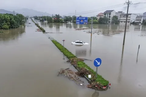
Typhoon Dolphin has torn through eastern China, dumping torrential rain across several provinces and forcing more than a million residents out of their homes. The storm made landfall in Zhejiang as the strongest typhoon to hit China this year. It has since weakened but is still dragging heavy rain deep into the country’s interior. Authorities are now watching Beijing closely. The capital could see a third of its entire annual rainfall in a single 24-hour stretch, and flood emergency responses have already been triggered on the city’s outskirts.
Background
Typhoon Dolphin formed over the Pacific and gathered strength quickly before turning toward China’s eastern coastline. It came ashore late on a Sunday evening in Yuhuan, Zhejiang province, packing sustained winds of around 151 kilometers per hour. China’s National Meteorological Center responded by issuing a red alert, the top level in the country’s typhoon warning system. That single move tells you how seriously officials were taking this storm. Red alerts in China aren’t handed out casually, and this was the first of the year at that severity level.
Zhejiang has been hit hard by storms before. Last month, Typhoon Bavi also made landfall in the same province and pushed 1.7 million people out of their homes. Dolphin is following a similar, punishing pattern.
Details
Winds from Dolphin reached as high as 150 kilometers per hour when the storm crashed into Shanghai and the surrounding coastline. More than a million people were evacuated across the affected provinces, and the disruption spread fast. Roughly 40 percent of flights out of Shanghai were grounded at the height of the storm. Public transport, including several local train lines, was suspended entirely in parts of the city. Streets in Shanghai’s main commercial districts sat underwater, and officials told residents to simply stay home if they could. Rainfall totals have been staggering. Parts of central and eastern Zhejiang are expected to receive somewhere between 250mm and 500mm of rain, which works out to roughly 10 to 20 inches. China’s Ministry of Water Resources has flagged the Qiantang, Yong, Jiao, and Shuiyang rivers as being at risk of major flooding, with smaller rivers in the worst-hit areas already rising past warning levels. Dolphin didn’t stop at the coast. After making landfall, it weakened into a tropical storm but kept pushing inland, soaking Anhui, Jiangsu, and Shandong provinces as it went. By Tuesday, it had churned into Hubei province, where forecasters warned that the mountainous northwest could see close to 10 inches of rain in a single day.
Hubei authorities issued yellow warnings for several cities, including Xiangyang, Huanggang, and Suizhou, citing the heightened risk of both flooding and landslides. Scenic areas across the province announced temporary closures as a precaution.
Beijing is now in the storm’s path too, even though the capital sits more than 600 miles north of Hubei. Four districts on the city’s outskirts have already activated Level I emergency flood responses, the highest tier available, ahead of expected heavy rain.
Quotes
China’s National Meteorological Center described the red alert as necessary given the storm’s intensity and the risk of geological disasters in mountainous regions. Officials in areas under red mountain-torrent warnings told residents directly to follow local evacuation orders rather than wait for conditions to worsen.
China Eastern Airlines said it was working to resume flights to Shanghai and Zhejiang in an orderly manner as conditions allowed, though normal schedules had not yet returned by early this week.
Impact
The regional impact of Dolphin is already significant, and it isn’t over. Flooding, landslide risk, and transport chaos have hit Zhejiang, Shanghai, Anhui, Jiangsu, Shandong, and now Hubei. Beijing’s flood defenses are being tested as the system pushes moisture northward.
Beyond China, the wider region is watching closely too. Japan’s Meteorological Agency has flagged its own concerns about landslides, flooding, and strong winds tied to storm activity moving through the same general path this typhoon season.
Economically, grounded flights and suspended trains carry real costs for businesses and travelers across one of China’s most densely populated coastal corridors. Agricultural regions in the path of the heaviest rain also face crop damage, something authorities typically assess in the weeks following a storm of this scale.
Conclusion
Typhoon Dolphin has weakened since making landfall, but the danger hasn’t passed. Forecasters expect the system to keep moving through central China over the coming days, with Hubei and now Beijing bracing for the heaviest rain still to come. Authorities are likely to keep emergency flood responses active in the capital’s outer districts through the next 24 to 48 hours. Whether Beijing avoids the worst of it will depend largely on how the storm’s remaining moisture behaves as it tracks north, something meteorologists say they’re monitoring closely in real time.
FAQs
What is a typhoon dolphin?
Typhoon Dolphin refers to a tropical cyclone named “Dolphin” under the Pacific typhoon naming system, where storms rotate through a shared list of names contributed by countries across the region. The name Dolphin was originally submitted by Hong Kong and refers to the Chinese white dolphin, a species considered a local mascot. Several storms have carried this name over the years, including the one currently affecting eastern and central China, which made landfall in Zhejiang province with sustained winds of over 150 kilometers per hour before weakening and pushing inland toward Hubei and Beijing.
What is the largest super typhoon?
Super typhoons are ranked using sustained wind speed, and the western Pacific has produced some of the most powerful tropical cyclones ever recorded. Typhoon Tip in 1979 remains widely cited as the largest tropical cyclone by diameter on record, while storms like Typhoon Haiyan in 2013 and Typhoon Meranti in 2016 rank among the most intense by wind speed, with sustained winds exceeding 305 kilometers per hour in some assessments. Classification as a “super typhoon” generally requires sustained winds of at least 240 kilometers per hour under the scale used by the Joint Typhoon Warning Center.
When was Typhoon Dolphin Guam?
An earlier storm carrying the name Dolphin passed near Guam in May 2015. It moved through the channel between Guam and Rota on May 15 of that year, producing typhoon-force winds on both islands and a wind gust of 106 mph recorded at Andersen Air Force Base. That storm later intensified further and was classified as a category five super typhoon by the Joint Typhoon Warning Center as it curved north, before weakening and becoming extratropical by May 20, 2015. It is a separate storm from the current Typhoon Dolphin affecting China, since tropical cyclone names are recycled every few years within the same regional naming list.