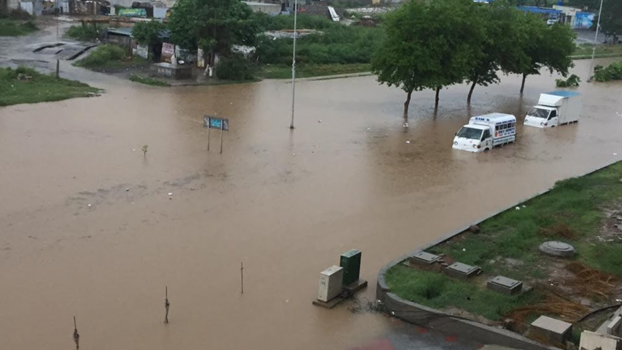
Heavy monsoon rain triggered flash flooding across Islamabad on September 1, 2026, submerging roads and basements in E-11, Park Road and Ghauri Town. The Capital Development Authority says the downpour was unusually intense, but an investigation into the disaster points to something closer to home: decades of unchecked violations of the city’s own master plan.
Background
Islamabad was designed in the 1960s as one of the most carefully planned capitals in the world, with dedicated green zones, wide rights-of-way for natural drainage channels, and low-density housing sectors. That plan has been amended more than fifty times since, according to Dawn’s reporting, and a full revision meant to modernise it has been stuck in bureaucratic limbo for years.
The result is a city where natural nullahs, the seasonal streams that carry rainwater off the Margalla foothills, have been squeezed, rerouted or built over by housing societies. When the monsoon delivers a heavy spell, that water has nowhere to go.
What Happened on September 1
The Pakistan Meteorological Department described the rainfall in Islamabad and Rawalpindi as the heaviest the twin cities had seen in three years. E-11 sector alone recorded around 150mm of rain in a short window, according to the district administration, enough to overwhelm the local stormwater channel entirely.
E-11 Sector Bears the Brunt
Water from the overflowing nullah poured onto roads and into basements across E-11. Officials said the worst-hit basements had already been sealed as a precaution, a decision that appears to have limited casualties in that specific sector this time. A protective wall in D-12/2 also collapsed during the rain, though rescue teams reported no injuries at that site.
Ghauri Town Phase II and the Park Road area near Comsats University also flooded badly. Authorities later said residents in Ghauri Town had blocked a drainage channel with concrete slabs, which made the flooding there worse.
Rawalpindi’s Nullah Lai Under Pressure
Just across the boundary in Rawalpindi, the water level in Nullah Lai rose to roughly 29.5 feet at Kattarian and 20 feet at Gawalmandi, prompting the district administration to shut educational institutions for the day. Rescue 1122 evacuated dozens of residents from low-lying areas along the stream.
The Rawal Dam, which feeds into the same catchment, saw its water level climb to 1,751.90 feet, forcing operators to open the spillways.
Official Quotes and Statements
CDA Chairman and Islamabad Chief Commissioner Sohail Ashraf said the authority plans four new check dams at the foothills of the Margallas to store rainwater, along with a new nullah in E-11 to improve drainage. He also promised that encroachments blocking the right-of-way of nullahs in Ghauri Town and elsewhere would be removed.
Asked about the years of neglect that preceded the crisis, Ashraf did not dodge the question. He said a crisis like this creates an opportunity, and that his administration intends to focus on storing rainwater in a city that otherwise struggles with water scarcity.
The Islamabad district administration, under Deputy Commissioner Irfan Nawaz Memon, said dewatering pumps and sanitation staff had been deployed at every affected site and that drainage operations continued through the following day.
Why Islamabad Keeps Flooding: Master Plan Violations
Dawn’s investigation into the flooding found that in each of the three worst-hit areas, the course of a nullah had either been altered or its right-of-way narrowed by private developers, often with the CDA’s own approval. In one case near E-11, a nullah that once had close to a 100-foot right-of-way narrows to about 18 feet with a sharp bend by the time it reaches the sector, after a housing society reduced it from an original 40 feet.
The CDA itself permitted that same society to cover over part of the nullah, according to the investigation. Further back, in the 1990s, the authority amended the master plan to reclassify Zone 4 from green space to residential land, opening the door to housing schemes in an area that was originally meant to absorb rainwater and protect the watershed.
Unregulated construction is not confined to the formally zoned sectors either. Large stretches of Zone III, including Shah Allah Ditta, parts of Bhara Kahu and land near Rawal Dam, remain under a construction ban that the CDA has no functioning mechanism to enforce, so building continues regardless.
Impact on Residents and the Capital
Beyond the immediate flooding, the crisis has renewed pressure on the CDA over basement safety, drainage capacity and the long-delayed master plan revision. Property owners in E-11 in particular are watching closely, since sealed basements still flooded despite precautions, raising questions about how deep the water intrusion problem actually runs.
The disruption also hit daily life across the twin cities. Traffic backed up on the Islamabad Expressway and other main roads, schools in Rawalpindi closed for the day, and commuters were advised to avoid low-lying underpasses until floodwater cleared.
For a capital that markets itself internationally as one of the world’s best-planned cities, repeated flash flooding in the same handful of sectors, including E-11, which also flooded fatally in 2021, has become an uncomfortable pattern rather than a one-off event.
Conclusion
The CDA’s own account of this flood points less to an unprecedented weather event and more to years of allowing that master plan to erode sector by sector. Chairman Ashraf’s promised check dams and nullah widening in E-11 would mark a real shift if they are completed, but Islamabad has heard commitments to fix its drainage before without a formal master plan revision behind them. Whether this round of flooding finally forces that revision through, after decades of stalled summonses to the federal government, is the question residents will be watching over the coming monsoon seasons.
Frequently Asked Questions
What is a flash flood?
A flash flood is a sudden, fast-moving flood that develops within minutes or a few hours of intense rainfall, often before an area has any real warning. Unlike slow-building river floods, flash floods usually happen when rain falls faster than the ground, drains or natural channels can carry it away, so water rises quickly in streets, basements, underpasses and low-lying neighbourhoods. Urban areas with concrete surfaces and blocked or narrowed drainage channels, like several sectors of Islamabad, are especially vulnerable because rainwater has fewer places to soak in or flow through safely.
What is the biggest flood in Pakistan’s history?
The 2010 floods are generally regarded as the most geographically devastating in Pakistan’s history, submerging roughly a fifth of the country and affecting an estimated 20 million people after the Indus River overflowed along its length. In terms of death toll and economic damage in a single season, the 2022 monsoon floods are often cited as the worst in recent memory, killing more than 1,700 people and causing over $30 billion in losses after unusually heavy rains combined with glacial melt in the north. Both events are frequently referenced when officials and experts discuss the country’s long-term flood risk.
What is the current situation in Islamabad?
As of early September 2026, the immediate flooding in Islamabad has been brought under control after emergency dewatering operations by the CDA and district administration. Authorities have sealed basements considered at risk, cleared blocked drainage channels and deployed additional pumps at the sectors that flooded worst, particularly E-11. The CDA has also announced plans for new check dams and a widened nullah in E-11, though these remain proposals rather than completed work, and the underlying master plan revision that experts say the city needs is still awaiting formal notification from the federal government.