
Every year, landslides and avalanches kill thousands of people worldwide — most of them in communities that had no warning, no time to evacuate, and no way of knowing the ground beneath them had already begun to move.
Researchers have developed artificial intelligence systems that allow for the early detection of landslide and avalanche risks. AI analyses radar satellite images and detects even minimal changes in the soil that are invisible to the naked eye — allowing for the tracking of ground movement days, weeks, or even years before a potential collapse.
The technology is now being deployed in real disasters and in high-risk communities before disasters strike — mapping thousands of landslides in hours, flagging unstable slopes years in advance, and detecting avalanches in real time through cameras and deep learning algorithms that never sleep and never miss a pixel.
What was once a problem of scale — too much ground to monitor, too little time after earthquakes and storms to map damage manually — is becoming a problem that AI is systematically solving.
Background
The threat from landslides and avalanches has not shrunk. It has grown.
Scientists note that such phenomena are becoming more frequent due to climate change and human activity.
Monsoon storms are intensifying. Traditional snowfall is being replaced by rain in mountain regions. Wildfires strip slopes of the vegetation that holds soil in place. And human development continues to push into terrain that geology has marked as unstable.
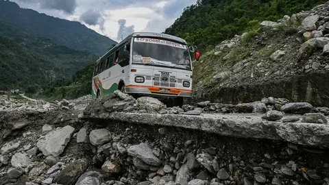
Approximately 75 percent of fatal landslides and avalanches occur in Asia, a region characterised by complex topography, high population density, and frequent triggers such as monsoons, earthquakes, and deforestation. South America follows with 8 percent, where landslides are commonly triggered by intense rainfall in mountainous regions.
Landslides and avalanches caused by earthquakes are among the deadliest combinations in natural disaster history. The 2008 Mw 7.9 Wenchuan earthquake in China resulted in the largest recorded landslide in history, with an estimated volume of 7.5 × 10⁸ cubic metres.
When the ground shakes, slopes that appeared stable for decades can fail within seconds — and in remote mountain terrain, the damage goes unseen for days.
That is exactly the problem AI is now being trained to solve.
How AI Detects Landslides and Avalanches
The core technology behind the new generation of AI landslide detection is InSAR — interferometric synthetic aperture radar — a satellite imaging technique that detects ground movement measured in millimetres.
A new approach that combines AI and satellite data has been used by scientists to detect actively moving landslides at a national scale. The semi-automated method combines machine learning with clustering tools and has classified more than 300,000 slopes around the UK, highlighting 3,000 slopes that have moved in a four-year period. The slopes deemed unstable affect approximately 14,000 km of road and 360 km of railway.
The value of this approach is not just what it finds — it is how fast it finds it. In the aftermath of a disaster, time really matters. Using AI, researchers identified 7,000 landslides after the Taiwan earthquake, within three hours of the satellite imagery being acquired.
The same process done manually would have taken days — days in which rescue teams would have been working blind, unable to prioritise the communities buried deepest under debris.
The Cambridge team is working to build AI models that can automatically identify landslides in satellite images even when cloud cover or darkness makes it hard to see them — combining cloud-penetrating radar with optical images to build a system that works in any weather, at any time of day or night.
For avalanches specifically, a separate system has been developed that detects them in real time using cameras and deep learning — tracking snow movement on steep slopes continuously and issuing alerts the moment mass begins to accelerate.
Landslides and Avalanches Caused by Earthquakes — The Hardest Problem
Of all the triggers for landslides and avalanches, earthquakes remain the hardest to respond to — because the landslides and avalanches caused by earthquakes arrive at the same moment the disaster response system is already overwhelmed.
Triggered by major earthquakes or intense rainfall, landslides are often worsened by human activities such as deforestation and construction on unstable slopes. In certain environments they can trigger additional hazards such as fast-moving debris flows or severe flooding, compounding their destructive impact.The Cambridge research group CoMHaz — focused specifically on cascading and multi-hazard disasters — is working to model these chain reactions. Their work on the 2024 Taiwan earthquake demonstrated what AI-powered detection can do when applied immediately after a major seismic event. The AI models identified 7,090 landslide events covering more than 75 km² within approximately three hours of the acquisition of Earth observation imagery — providing a preliminary inventory that supported both immediate rescue prioritisation and longer-term seismic hazard modelling.The AI tools tracking landslides and avalanches caused by earthquakes also help with the secondary risk: aftershocks. AI earthquake forecasting tools can forecast the risk of aftershocks seconds after the initial tremor — giving slope stability models the early input they need to flag which areas are most likely to experience secondary landslides before rescue teams enter them.
The Nepal Early Warning System — AI on the Ground
The most tangible current application of AI to landslides and avalanches is the SAFE-RISCCS system being piloted in Nepal — one of the world’s most landslide-vulnerable countries.
The SAFE-RISCCS platform combines local data, satellite imagery, and advanced algorithms to identify unstable ground and provide early warnings. Nepal is particularly vulnerable to landslides due to its mountainous terrain, unstable geology, shifting rainfall patterns, and the impact of climate change. Traditional snowfall is increasingly replaced by rain, wildfires contribute to soil erosion, and monsoon storms are becoming more intense.
The system is currently being tested in two high-risk areas — Kimtang in the Nuwakot district and Jyotinagar in the Dhading district. The system has already identified a large unstable area beneath Kimtang village, marking it as a high-risk zone for a devastating landslide.
Community members play a direct role in making the system work. Local residents including primary school teachers collect rainfall data using simple rain gauges. This local data is combined with satellite imagery and AI-driven analysis to forecast potential landslides weeks in advance — making the system both technically advanced and practically grounded in the communities it protects.
The Transparency Problem — Why Trust Matters
The most sophisticated AI landslide detection system in the world is only useful if the people responsible for acting on its outputs trust what it tells them.
AI can feel like a black box. Its internal logic is not always transparent, and that can make people hesitant to act on its outputs. In high-stakes scenarios like disaster response, trust in AI-generated results is crucial. Researchers are working to incorporate features that explain the AI’s reasoning — using visualisations such as maps that show the likelihood of an image containing landslides to help decision-makers understand the outputs and act with confidence and speed.
The challenge is that the people who develop AI landslide detection algorithms are very often not the people who must act on their recommendations. Local emergency managers, village officials, and evacuation coordinators need to understand not just what the AI is flagging, but why — and they need that explanation in a form that translates directly into a decision about whether to evacuate or stand down.
Getting that communication right is the next frontier in using AI to protect communities from landslides and avalanches.
Landslide vs Mudslide — What Is the Difference
These terms are frequently confused, and in disaster reporting they are often used interchangeably. The distinctions matter both scientifically and practically.
Landslide is a more general term than mudslide. It refers to the gravity-driven failure and subsequent movement downslope of any type of surface material — soil, rock, or debris. The term incorporates earth slides, rock falls, flows, and mudslides, among other categories of mass movement.
A mudslide — more precisely called a mudflow — is a specific type of landslide in which fine-grained material saturated with water flows rapidly downslope. A mudflow is a mass of water and fine-grained earth materials that flows down a stream, ravine, or canyon. If more than half of the solids in the mass are larger than sand grains — rocks, stones, boulders — the event is called a debris flow rather than a mudflow.
In terms of landslide vs mudslide, the simplest way to understand the distinction is this: every mudslide is a landslide, but not every landslide is a mudslide. A rockfall, a deep-seated slope failure, and a submarine landslide on the ocean floor are all landslides — none of them are mudslides.
Debris Avalanche — The Fastest and Most Destructive Type
The debris avalanche is a term that sits at the intersection of landslides and avalanches — and it is one of the most dangerous phenomena in the entire spectrum of ground movement.
A debris avalanche is a fast-moving debris flow that travels faster than about 10 mph. Speeds in excess of 20 mph are not uncommon, and speeds in excess of 100 mph, although rare, do occur locally. Debris avalanches and debris flows are shallow landslides, saturated with water, that travel rapidly downslope as muddy slurries — carrying rocks, bushes, and other debris as they pour down slopes.
Some devastating forms of landslides and avalanches, such as debris avalanches and mudflows, can reach speeds over 249 miles per hour and are capable of burying entire communities.
At those speeds, there is no warning and no escape for anyone in the path of the flow.
Large-scale debris avalanches are associated with many volcanic areas including Augustine Volcano in Alaska, Bandai-san in Japan, and Mount St. Helens in Washington. Large-scale landslide deposits have been found off the coast of several Hawaiian islands.
The debris avalanche at Mount St. Helens in 1980 remains the largest in recorded history on US soil — triggered not by rain but by a volcanic eruption that destabilised the entire northern face of the mountain in seconds.
Quotes
“In the aftermath of a disaster, time really matters.”
— Lorenzo Nava, Research Associate, Departments of Earth Sciences and Geography, University of Cambridge
“In high-stakes scenarios like disaster response, trust in AI-generated results is crucial. Through this challenge we aim to bring transparency to the model’s decision-making process, empowering decision-makers on the ground to act with confidence and speed.”
— Lorenzo Nava, University of Cambridge
“Their village is actually located on an unstable slope.”
— Antoinette Tordesillas, Researcher, on the AI system’s identification of Kimtang village in Nepal as a high-risk landslide zone
“AI allows not only to predict disasters but also to plan evacuations, identify safe zones, and reduce risks to infrastructure.”
— Researchers quoted by BBC, on the capabilities of current AI landslide and avalanche detection systems
Impact
For disaster response, the ability to map thousands of landslides and avalanches within hours of a major earthquake represents a genuine revolution in how emergency teams can work. Similar algorithms can process huge amounts of data much faster than humans and identify thousands of potentially dangerous slopes. The technologies were used to map over 4,000 landslides after a disaster in Indonesia, which helped rescuers assess the situation on the ground.
For vulnerable communities, systems like SAFE-RISCCS in Nepal offer something more valuable than faster disaster response — they offer the possibility of prevention entirely. A village warned weeks in advance that the slope beneath it is moving has options. A village that learns this information when the hillside gives way has none.
For climate adaptation, the acceleration of landslides and avalanches caused by changing rainfall patterns, retreating glaciers, and more intense storms makes AI monitoring not a luxury but a necessity. Europe has faced wave after wave of climate-driven disasters — in Switzerland, a glacier collapse triggered a deadly landslide that engulfed a small alpine village, while flash floods across southern Europe hit with increasing intensity. The tools being built today to detect ground movement in Nepal and Taiwan are the same tools that will protect communities from landslides and avalanches in the Alps, the Andes, and the Himalayas as the climate continues to shift.
FAQs
What is a landslide and avalanche?
A landslide is the outward and downward movement of numerous materials like earth and debris on a wet slippery surface. It includes five types of slope movement — flows, spreads, slides, falls, and topples — and can take place in mountains, coastal cliffs, and even underwater. An avalanche is the movement of a large mass of ice or snow down a steep terrain, triggered by the unique interaction between the terrain, weather, and the snowpack.
Both landslides and avalanches are gravity-driven phenomena, but their material, environments, and behaviours differ significantly. Landslides involve soil, rock, or debris. Avalanches involve snow and ice. AI detection systems now monitor both — using satellite radar data for landslides and real-time cameras with deep learning for avalanches.
What are the 7 natural disasters?
The most commonly cited categories of natural disasters are earthquakes, volcanic eruptions, tsunamis, hurricanes and cyclones, floods, wildfires, and landslides and avalanches. Landslides and avalanches can lead to significant loss of life and property, often causing more fatalities and damage than many other natural disasters combined.
Each category can also trigger the others — earthquakes cause landslides and avalanches, wildfires strip slopes and cause mudflows, and underwater landslides trigger tsunamis. The connections between these events are precisely what the Cambridge CoMHaz research group is working to model and predict using AI.
Is landslide the same as avalanche?
A landslide is a form of mass wasting that includes the movement of a large area of land under the force of gravity, while an avalanche is a type of landslide that occurs specifically in snowy regions. While the mass in landslides contains soil, rocks, or mud, avalanches are made primarily of snow and air. Landslides happen on land with steep slopes while avalanches happen in snowy mountain regions where snowpacks are weakly held.
The simplest distinction is this: all avalanches are a form of landslide, but most landslides are not avalanches. A debris avalanche — which involves saturated soil and rock moving at high speed — sits between the two, sharing characteristics of both and representing one of the fastest and most destructive forms of ground movement that AI systems are now being trained to detect and predict.
Conclusion
When the Earth moves, it rarely announces itself. Landslides and avalanches arrive without ceremony — seconds of ground tremor, minutes of rain, or years of imperceptible slope creep that one day reaches the point of no return.
AI is not eliminating that unpredictability. But it is shrinking the window between the moment the ground begins to move and the moment someone with the power to act finds out about it.
AI allows not only the prediction of disasters but also the planning of evacuations, identification of safe zones, and reduction of risks to infrastructure.
For the communities living beneath the world’s unstable slopes — in Nepal’s mountain districts, in Indonesia’s river valleys, in Switzerland’s alpine villages — that shrinking window is the difference between a disaster and a warning. Between a tragedy and a decision.
The ground has always told the truth. AI is finally learning to read it.