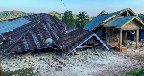
A powerful 7.7 magnitude earthquake Indonesia disaster struck off the coast of Flores Island early Saturday morning, killing several people and injuring others. The quake triggered a tsunami warning across four provinces before it was later lifted. Authorities continue to assess the scale of destruction as aftershocks keep rattling the region.
Background
Indonesia sits directly on the Pacific Ring of Fire, a horseshoe-shaped belt around the Pacific Ocean known for intense seismic and volcanic activity. The archipelago nation regularly experiences powerful tremors because of its location where several tectonic plates meet and grind against one another. This latest 7.7 magnitude earthquake Indonesia event adds to a long list of major quakes the country has endured over the past two decades. The region of East Nusa Tenggara, where the quake struck, has a documented history of seismic events, according to tectonic summaries from international monitoring agencies. Communities living along this coastline are accustomed to earthquake drills and evacuation protocols. Even so, the intensity of Saturday’s shaking caught many residents off guard.
Details
The United States Geological Survey (USGS) confirmed that the earthquake hit at 5:58 a.m. local time on Saturday. The epicenter was located approximately 68 kilometers north-northwest of the city of Ende, in the East Nusa Tenggara province, at a shallow depth of around 10 kilometers. Shallow earthquakes of this kind tend to cause more surface damage compared to deeper tremors of similar magnitude.
Indonesia’s Meteorology, Climatology and Geophysics Agency (BMKG) swiftly issued a tsunami warning covering East Nusa Tenggara, West Nusa Tenggara, South Sulawesi, and Southeast Sulawesi provinces. Residents living near beaches and riverbanks were urged to move immediately to higher ground. The warning was lifted several hours later once officials confirmed the tsunami threat had passed. At least eleven aftershocks followed the main tremor within a short span of time, with the strongest measuring magnitudes of 5.9, 5.6, and 6.1. These repeated jolts added to the panic among residents already dealing with collapsed structures and blocked roads. USGS estimates suggest more than half a million people on Flores Island experienced very strong shaking, while several million more across the wider region felt moderate to strong tremors. Local television footage showed extensive damage to buildings around the Maumere region, with houses reduced to rubble and streets littered with debris. Hospitals in the affected areas moved patients outdoors as a safety precaution, setting up temporary treatment areas with beds, IV stands, and oxygen cylinders on open ground. Emergency crews have been working since dawn to clear roads and reach isolated villages.
Quotes
Yohanna Embu, a resident of Sikka regency in East Nusa Tenggara, described the chaos that unfolded as the ground began shaking violently. She said several buildings in her area sustained heavy damage and that panicked residents fled toward higher ground the moment the tremor started. Her account matches similar testimonies emerging from villages across the affected coastline. East Nusa Tenggara police chief Rudi Darmoko confirmed that preliminary reports indicated casualties in both Sikka and Manggarai regencies, with authorities still verifying the exact toll as search operations continue. Indonesia’s national disaster mitigation agency, BNPB, has also been issuing regular updates as rescue teams reach more remote locations.
Impact
Casualty figures remain fluid as different regional authorities report varying numbers, but multiple credible outlets place the death toll between two and five people so far, with several more injured. Officials caution that this figure could change as rescue teams reach areas that remain difficult to access due to damaged infrastructure. The full scale of destruction across Flores Island is still being assessed by disaster response teams on the ground. Beyond the immediate human toll, the 7.7 magnitude earthquake Indonesia event has disrupted daily life for hundreds of thousands of residents. Displaced families are sheltering in open spaces and temporary camps while structural engineers inspect damaged buildings for safety. Local businesses, schools, and hospitals in the affected regencies have also had to suspend normal operations. According to USGS ground-failure modeling, the region faces a heightened risk of earthquake-triggered landslides in the coming days, particularly in hilly terrain already weakened by the shaking. Authorities have warned residents in high-risk zones to remain alert and avoid unnecessary travel through mountainous areas until further geological assessments are completed.
Conclusion
Indonesian authorities are expected to release updated casualty and damage figures over the coming days as search and rescue operations expand across East Nusa Tenggara. International agencies, including the USGS, continue to monitor the region for further aftershocks, some of which could still pose risks to already weakened structures. Humanitarian organizations are also preparing to assist with relief supplies and temporary shelter for displaced families. This latest disaster once again highlights Indonesia’s vulnerability to major seismic events given its position along the Pacific Ring of Fire. As recovery efforts continue, the government’s response in the coming weeks will be closely watched, particularly regarding reconstruction support and long-term disaster preparedness measures for coastal communities.
FAQs
How many people died in the Indonesia tsunami in 2018?
The Indonesia tsunami of 2018 struck the city of Palu on Sulawesi island in September of that year, following a powerful 7.5 magnitude earthquake. The combined earthquake and tsunami killed thousands of people, with official death tolls reported at well over four thousand victims once search and recovery operations concluded. The disaster also triggered soil liquefaction in several neighborhoods, which buried entire communities and made the recovery process especially difficult for rescue teams.
When did the 9.5 earthquake happen?
The strongest earthquake ever recorded by modern instruments occurred in 1960 near Valdivia, Chile, measuring a staggering magnitude of 9.5. This massive quake triggered a Pacific-wide tsunami that caused destruction not only across Chile but also in Hawaii, Japan, and the Philippines. It remains the benchmark against which all other major earthquakes, including those in Indonesia, are compared by seismologists worldwide.
Which country had the worst earthquake?
Historically, the deadliest single earthquake on record struck Shaanxi province in China in 1556, killing an estimated 830,000 people due to the collapse of cave dwellings where many residents lived. In terms of instrumentally recorded magnitude, however, the 1960 Chile earthquake remains the most powerful ever measured. Indonesia, meanwhile, has suffered some of the deadliest tsunami-related disasters in modern history, including the catastrophic 2004 Indian Ocean tsunami that killed more than 220,000 people across multiple countries.